Sunday, November 20, 2011

Delhi, Eastern Rajasthan and Agra - February 2010

The trip was planned suddenly. Multiple considerations needed to be addressed. We were travelling with Sirshendu, my KMDA colleague, and his wife. A journey on the newly introduced Sealdah – New Delhi Duronto was compulsory. For Durba, Sirshendu and Deboleena (Sirshendu’s wife), we had to thow in a Rajdhani ride. A visit to the Taj Mahal was must (I specifically intended it as an anniversary event for Durba and myself). It could have been a Delhi – Jaipur – Agra golden triangle tour. But after taking everything into account, we decided to include Udaipur as well. Finally, the itinerary looked like this:
February 18 – Board the evening Duronto from Sealdah.
February 19 – Arrive in Delhi by noon. Quick rest and lunch at the ITPI guest house. Then visit the Qutb Minar, the Baha’i Temple and Humayun’s Tomb in the afternoon. Board Mewar Express to Udaipur from Hazrat Nizamuddin in the evening.
February 20 – Arrive at Udaipur early in the morning. Check in at the ITPI guest house. Spend the day sight-seeing. Overnight stay at the guest house.
February 21 – Visit to Chittorgarh Fort and back to Udaipur (Nathdwara and Haldighati were thrown as additions on the spot). Start for Jaipur in the evening by the Agra express.
February 22 – Arrive at Jaipur early in the morning. Check in at the ITPI guest house. Spend the day sight-seeing (We did the Museum, the Jantar Mantar, the City Palace and the Aamer fort during the day. The evening was spent at the Chokhi Dhani grounds). Night-stay at the ITPI guest house.
February 23 – Take a car in the morning to visit Pushkar and Ajmer and return to Jaipur in the evening. Night-stay at the ITPI guest house.
February 24 – Visit to the Jal Mahal and the Jaigarh and Nahargarh forts during the day. Some shopping post-lunch. Then board an evening bus to Agra. Reach Agra late at night. Check in at the Shanti Lodge.
February 25 – Visit to Taj Mahal at first light. Visit to Agra fort and the other places of interest in Agra during the day. Then back to the Taj to experience it in its evening glory. Night-stay at the Shanti Lodge.
February 26 – Take a car to Delhi in the morning. Stop-over at Fatehpur Sikri en-route. Night stay at the ITPI guest house.
February 27 – Durba and I ended up visiting the Jama Masjid and lunching at Karim’s. Board the Sealdah Rajdhani from New Delhi station in the evening.
February 28 – Back to Kolkata in the morning.
Udaipur
I cherish: visit to the palace, the ropeway ride to the temple of Charani Mata, boat ride on the lake.
From Udaipur, February 2010
Udaipur, February 2010
Chittorgarh
I remember most - the exciting climb up the Victory Tower.
From Chittorgarh Fort, February 2010
Chittorgarh Fort, February 2010
Jaipur
Jaigarh fort tops my list. Aamer is a close second. Lost in history, one is transported several centuries back in time. The afternoon we went to Aamer, Jaipur’s clear blue skies suddenly clouded over and it began to drizzle. The locals said that it was raining after a very long time. We had bought camel-skin shoes from a shop and wore them to Chokhi Dhani in the evening. The drizzle suddenly gave way to an intense downpour that was preceded by a dust storm, thunder and flashes of lightning. The grounds turned mucky and our new camel-skin shoes paid the price! I also remember the acute stomach upset I picked up on our last day at Jaipur, with me sitting anxiously through the entire bus ride to Agra as a result!
From Jaigarh and Nahargarh Forts, Jaipur, February 2010
Jaipur, February 2010
Aamer Fort, Jaipur, February 2010
Jaigarh and Nahargarh Forts, Jaipur, February 2010
Agra
One big solid-looking Norflox pill did the trick! I was fit for the early morning visit to the Taj after sleeping late at night. Research on the web earlier had suggested that the Shanti Lodge, in old Agra, would be a great place to stay. The Taj was a five-minute walk and the rooftop cafĂ© was supposed to offer unparalleled views of the edifice. We had booked in advance accordingly. However, when we reached late at night, the staff did not seem too eager to check us in. It dawned on me later that the Shanti Lodge being a preferred address for foreigners, thanks to extensive coverage on Lonely Planet and other international travel literature, the staff is generally apprehensive of the quality of Indian guests. It may sound discriminating but then, it’s understandable that foreign guests would probably not enjoy loudness and other forms of trouble which, unfortunately, some of our countrymen are prone to perpetrating. Shanti Lodge definitely has its advantages in terms of location and view. But it may not be the most comfortable place to stay for all Indians.
The Taj is one of my happiest memories till date. Will remember the walk (the run, rather, rushing as we were to be one of the first visitors of the day) with badly-cracked and painful heels through the winding lane from the Lodge to the Taj. Time seems to have stopped in the alleyways of the old settlement around the Taj, said to be first inhabited by the workers who built the monument. Seeing the Taj through the mist in the first light of the day (my first glimpse ever) made me feel I had fulfilled a major objective of not only this tour but of my entire life till date as well. I returned with a deep sense of peace and calm.
When we visited the Taj in the evening again, a small incident happened –there was some insult from the security forces at the entry who suspected us of being Bangladeshis! Well, probably there have been cases of guests from our neighbouring countries entering with tickets meant for Indians, which are cheaper than the ones meant for foreigners. Probably there was a genuine security concern. Whatever it was, it left a bad taste in the mouth. Still, at the end of the day, when you have experienced the Taj withdrawing into its centuries-old shell of graceful silence in the fading daylight, and seen the full-moon shining behind it, you learn to take lightly the trivia of life…
From Taj Mahal, February 2010
Taj Mahal, February 2010
Agra, February 2010
Agra Fort, February 2010
Fathepur Sikri, February 2010
Delhi
We were about to leave Humayun’s Tomb in the evening. Our train to Udaipur would start from Nizamudding in half an hour. The sun had set and in the half-light of dusk, the place looked eerie. I suddenly found myself all alone in one of the cells of the Tomb. On one side was a jali through which the last light of the day filtered in. It was almost as if there was a presence other than mine in that confined space. Spooky feeling! It took me some time to get over it and get out of the chamber.
The other memory of Delhi from the tour is that of the Jama Masjid on the day of our return. While we were going round the courtyard of the Masjid, Durba and I suddenly came across a signboard announcing the sale of tickets for a passage up one of its soaring minarets. The forts of Rajasthan had worn down our knees and we were apprehensive of another long and steep climb. But in the end we decided to give it a try. We wound our way slowly to the top where a stupendous sight awaited us – all of Chandi Chowk lay sprawled out below and we could see the Red Fort in the distance, a shining streak behind it announcing the presence of the Yamuna. People and traffic, a multitude of the miniature, combined to resemble a slow moving river. One of the most exhilarating views on any tour so far…
IMG_2361


Tour Map

View Delhi, Agra and Eastern Rajasthan tour in a larger map

Monday, November 7, 2011

Sindhudurg, Belgaum, Goa - an office tour in September 2008

September 2008. I was working in IPMSL’s Research and Advisory unit at Kolkata. We had a client based at Sawantwadi, a town in Maharashtra’s Sindhudurg District. The gentleman wanted us to do a best-use study for a property at Amboli Ghat, a hill station in the Western Ghats, an hour by road from Sawantwadi. And so, I was sent to Sawantwadi. I flew down to Goa by Kingfisher. It was a hopping flight via Mumbai. The departure time from Kolkata was perfect – nine in the morning. The girl at the check-in counter was all smiles as she wished me a happy journey to Goa. It was a weekday and holiday season was nowhere near the corner. It was probably unusual to be flying to Goa direct from Kolkata under such circumstances. In fact, not too many people were booked through to Goa – almost all would get off at Mumbai.
It was a very pleasant flight, my best till date in fact. While flying over the Western Ghats, we came down low at one point and kept circling for a long time – the rugged forested terrain was spectacular to watch. After a half-an-hour stopover at Mumbai, we were on our way again. We had a fresh crew and new passengers from Mumbai and were flying at a relatively low altitude over the Arabian Sea shoreline. Goa is just half-an-hour’s flying time from Mumbai. From my right hand side window, I could see long stretches of beach shining below. From above, the waves of the Arabian Sea looked like thin white lines moving lazily towards the shore. As we crossed Sawantwadi, the weather changed. A sea of clouds obstructed the ground view as we approached Dabolim, where Goa’s airport is located.
Dabolim International Airport is a civilian enclave in defence territory – the Indian Navy runs the base. There was a long queue of flights on the ground and it took us quite a while to taxi to the terminal after we had landed. I came across an interesting account on Dabolim Airport once on the net. Apparently, it was the Portuguese, the then rulers of Goa, who had set up an airfield at Dabolim in the fifties. Goa was serviced by Portugal’s TAIP airline. The first flight to land at Dabolim was flown by Major Solano De Almeida, who was instrumental in developing Dabolim and TAIP. In the December of 1961, the Indian army advanced into Goa. Dabolim was bombed and the runway, destroyed. The account says that in the middle of the military action, Major Solano de Almeida piloted what was probably the last flight out of Goa, flying the families of some of Portugal’s officers. He took off bravely from the damaged runway and flew low to avoid confrontation with the IAF. With some fictional inputs added, it would probably make a good period movie.
From Dabolim I took a cab to Sawantwadi. The drive, on the Goa – Mumbai National Highway, was around two hours. Sawantwadi, as I said earlier, is in Maharashtra’s Sindhudurg district, which lies just across the border of Goa. A beautiful lake called Moti Talao lies at the entry to the town, just off the NH. It was a joy to walk around it – the precincts were maintained beautifully and for a while, it didn’t seem like India to me! Yatin, my colleague from Mumbai, had been assigned for this mission as well and had arrived at the hotel before I did. He had gone out on a recce and we met in the evening.
We had planned to visit Amboli the next day and Yatin had already booked a Sumo. We started early. Driving eastwards from Sawantwadi, we climbed gradually up the winding Sawantwadi – Amboli – Belgaum State Highway. The valleys below were and green and fresh from the monsoon rain. The hilltops were hidden in clouds. The wayside was dotted with small cascades. It was chilly and misty in Amboli, a sleepy little place with a few hotels that somehow did not look very welcoming. But there was a certain charm about the place and the weather was magnifying the effect.
From Sindhudurg, Belgaum, Goa - September 2008
We were back to Sawantwadi before noon. I said that we should use of the rest of the day to look around the district. So we drove up north on the Goa – Mumbai NH. We crossed the industrial estate at Kudal and turned left from the NH to reach Oros, the district headquarters. The place had apparently been renamed as Sindhudurg Nagari. Sindhudurg is a newly created district and the district administration was housed in a new building. We went to the Town Planner’s office for some data. From Oros, we continued our journey northward, reaching the town of Kankavli, where we took a left on to the Kankavli – Achara Road. Achara is a small port on the Konkan coast. Just before entering Achara, a left turn took us on the road which is shown on Google Maps as MSH-4. This is supposed to be a coastal highway parallel to the Mumbai – Goa NH.
Heading south on MSH-4, we were going to the town of Malvan now. Sindhudurg Fort, after which the district is named, is situated on an islet on the Arabian Sea just off the coast of Malvan. It is one of the many forts Shivaji had built during his reign. We came to the small harbour at Malvan. The sun was low over the Arabian Sea. I don’t remember why we didn’t visit the Fort which rose out of the sea just across the harbour. Probably someone had said that it was closed at this time of the year. Anyway, we were on our way soon and the next stop on our southward journey on the coastal highway was at the Maharashtra Tourism Development Corporation Ltd.’s resort on the Tarkarli beach. The cottages had interesting ethnic designs. The sun had set and, saying goodbye to Tarkarli in the last light of the evening, we started on our journey back to Sawantwadi. Driving down the MSH-4 till Vengurla, we could see occasional glimpses of the Arabian Sea till the time it grew completely dark. It was a long day and we were completely tired. I regret that we didn't get the opportunity to visit the other sea-forts in the district - Vijaydurg and Devgad, which were not very far from Malvan.

The next day we were headed for Belgaum city in Karntaka. But before leaving Sindhudurg district, we did a quick tour of Aronda, the river ferry crossing point on the Trekhol river on the Maharashtra – Goa border. From Aronda we travelled to the beach at Shiroda. The drive was through mining country. Iron ore laden trucks were making their way slowly on the winding slopes. The sparkling blue waters of the Arabian Sea were a treat to watch at Shiroda. Our journey to Belgaum from Shiroda took us through Amboli again. We reached late in the evening.
Belgaum is a major city in Karnataka state. Interestingly, in Karnataka, it seemed to be referred to as Belagavi while, just across the border, it was Belgaon. There is a mix of Maharashtra and Karnataka here and there is a running issue over ownership of the city between the states. Yatin and I wanted to speak to some of the members who could give us an insight into the real-estate scenario in the city from the point of view of High Networth Individuals or HNIs. So we walked into the Belgaum Club with Yatin the next evening without any references whatsoever. It was an interesting little adventure, but our job was done.
The next day we had a meeting in the morning with a gentleman who had been kind enough to entertain our queries at the Belgaum Club the earlier evening. Meeting over, we were finally head for Goa, the last market we needed to study for the assignment. But we wouldn’t be taking the NH to Goa. Instead we took the State Highway to Chorla. The reason was that we wanted to visit the Wilderness Resort near Chorla Ghat. The road was bad to the point of being almost un-negotiable in parts. We were passing through stretches of forests and our Sumo was making heavy weather of it. Few vehicles seemed to ply this route. Help would be very difficult to find if we broke down in the middle of the road. It was an adventure alright. I was amazed to see a Kadamba (Goa State Transport) bus emerging out of nowhere all of a sudden, swaying dangerously from side to side as it went in and out of the potholes. I felt pity for the passengers.
We stopped at a resort which I think is called Wanderlust. It was closed for the time being. But we took a look around. Soon afterwards, the road improved. We had crossed into Goa and the drive had become pleasurably smooth. Close by, Chorla awaited us. We were crossing the Western Ghats – the Sahyadris – into the beach country of Goa. But Goa is not all about beaches. It is also about Chorla I would say. A green valley stretched out below us. A line of hills rose in the distance. We stopped to take it all in, soaking in the silence, and the soft sound of the breeze. It was worth the arduous drive.

A few kilomters down the road lay what we had come to see – the Wildernest Resort. We went and requested a tour, which the resort administration was kind enough to grant. It was a sprawling property laid out on the Ghat slopes. A short jeep drive on an earthen road brought us to where the cottages were located. Entry to the cottages was through narrow pathways almost hidden in dense foliage. The sun was setting when we arrived at what is definitely one of the most beautiful design creations I have ever seen – a vanishing pool overlooking the Sahyadris, reflecting the orange glow of the sunset. It was a sight that made us forget the strain, the targets, the deadlines…everything! As we reluctantly made our way out of Wildernest, Yatin and I both wished we could come and stay here for a whole week sometime. It was time to hit the road again and we drove downhill in the gathering gloom. To our right we could see lights twinkling at the edge of what looked like a huge reservoir. We reached the plains at last and driving past the industrial estate at Bicholim, arrived at Panjim.

It was a Saturday but we limited ourselves to Panjim only, not venturing out to Baga or Calangute for the evening. The next day, Yatin had an allergy – swellings near his elbows which he said were due to the seafood. We went down to Calangute in the morning. Sipping King’s, the delightful local beer, I sat reflecting on the tour. All those places we had visited – hill station, beaches…What an interesting collage they would make! That evening we went to Baga. A long and demanding tour had made us best buddies. It was the last evening of the tour. I would be going back from Dabolim the next day by the afternoon flight to Kolkata, taking with me vivid memories of the green Ghats, the beautiful Konkan coast, the Malvani cuisine, the seafood…memories which I revisited today as I wrote out his post at one go…
Tour Map

View Sindhudurg, Belgaum, Goa Tour in a larger map


Tour Itinerary

Sept 22 - Kolkata - Goa by flight by Mumbai; Goa - Sawantwadi by cab; Night stay at Swantwadi
Sept 23 - Sawantwadi - Amboli - Swantwadi - Kudal - Oros - Kankavli - Malvan - Tarkarli - Vengurla - Sawantwadi; Night stay at Sawantwadi
Sept 24 - Sawantwadi - Aronda - Shiroda - Sawantwadi - Amboli - Belgaum; Night stay at Belgaum
Sept 25 - In and around Belgaum city; Night stay at Belgaum
Sept 26 - In and around Belgaum city; Night stay at Belgaum
Sept 27 - Belgaum - Chorla - Bicholim - Panjim; Night stay at Panjim
Sept 28 - Day spent at Calangute and Baga; Night stay at Panjim
Sept 29 - Flight back to Kolkata via Mumbai
Tour Album
Sindhudurg, Belgaum, Goa - September 2008

Sunday, November 6, 2011

Goa, September 2009

Durba and I had spent a week in Goa in end-September, 2009. It was the Durga Puja week. We boarded the 8047 Amaravathi Express from Howrah on the night of September 24 (the night of Sasthi). Oh, the discomfort a couple has to endure on a 40 hr railway journey if allotted seats away from each other! Well, we did manage in the end. But suffering the old and badly maintained 2A coach through two nights and a day and a half was another ordeal, which was to revisit us on the way back, when we boarded the 8048 Amaravathi from Madgaon. Ome may ask why then did we opt for the railway journey and this particular train? Well, I wouldn’t deny that we were constrained by our budget in considering flight travel. But, there happened to be another reason as well. There is a stretch of the Western Ghats through which the Amaravathi Express passes on the last leg of its journey from Karnataka to Goa. On this stretch, lies the Dudhsagar, one of India’s highest waterfalls, a sight to watch as it cascades down hundreds of feet right onto the railway track. Well, almost, that is! It is especially awesome to watch if one happens to be passing through in the middle of the monsoons. We thought we would take this opportunity to experience the Dudhsagar, and the Braganza Ghats (as the Western Ghats are known as in this stretch).
From Goa, September 2009
Apart from the customary sunset at Miramar, the walk from Calangute to Baga, and the visit to Old Goa, Dona Paula and Colva, this tour is memorable for:
The train journeys through Dudhsagar and Braganza Ghats – The Ghat section lies between Castle Rock in Karntaka and Kulem in Goa. 8047 reached Castle Rock at 11-20 hrs. 8048 reached Kulem at 8-20 hrs. The windows of our fit-to-be-condemned 2A coach on both the journeys were stained to the point of being opaque. We caught the entire section standing in the doorway, which we had occupied early enough, gaining from our prior homework. There was this dilemma about which side to stand on. Travelling in to Goa, Dudhsagar falls on the left. To catch another glimpse of it after one has actually passed underneath the falls, one has to move to the right hand side doorways, as the train takes a horseshoe curve downhill afterwards. It’s a a beautiful journey through a dense forest, and is dotted with tunnels and characterized by steep curves. One should not miss it if travelling on the Amaravathi into or out of Goa. It totally redeemed the long journey to and fro between Kolkata to Madgaon. Below there are two movie clips of 90 seconds each of the up and down journeys through the Ghats.

View Braganza Ghats, Madgaon in a larger map


Chapora Fort – We have all seen it in Dil Chahta Hai. There are no ruins here. Just a grassy hilltop with a peripheral wall. But the views all round are superb. I remember looking at the mouth of the Chapora River far below and wishing we could take a boat upstream.
From Goa, September 2009
Palolem – Reminded me of the Caribbean beaches seen on TV and the net. It was raining and we were trying to get to the small island that lies just across the beach at one end. We had to wade across a narrow stream to reach the island. Though the water was not deep, there was a very strong current. We didn’t make it to the island in the end. One had to swim across a small channel. Some of the Israelis/Russians who had come in a group were trying it out. We visited the Agonda beach close to Palolem. I do not remember any other instance of being on a beach all by ourselves. Well, it was drizzling throughout…
Lunch at the Hospedaria Venite – This is a quaint old restaurant on the 31st January Road in Panjim. The food was very good, as were the interiors. The floor is apparently made of planks salvaged from old shipwrecks.
From Goa, September 2009
The food in general – Will never forget the amazing sea food, the Recheados, the squid rings, the fried fish and shrimps, and the liquor.
We also remember the tour for the incessant rain which marked its second half. Goa is lovely in the rains, no doubt. But then, what had started as a drizzle turned in to a deluge! We cancelled our plans for a day journey to Mumbai on the Konkan Railway, and from there onwards to Howrah, opting instead for the direct journey back on Amaravathi Express, for which we had another set of tickets. Had it been the next day, we may just as well have got stranded in Goa! A terrible flood had inundated large swathes of Karnataka, cutting off the Goa line altogether. We saw glimpses of it on our journey - floodwaters rushing across a level crossing near Bellary station, cattle fleeing in droves, people crowding into the sleeper coaches of our train which probably was the only passing through that day.

Tour Itinerary
Sept 24 – Boarded Amaravathi Express at Howrah. Departure sometime close to midnight.
Sept 25 – On train.
Sept 26 – Close to noon crossed the Braganza Ghats and Dudhsagar Falls. Arrived Madgaon around 2 in the afternoon. Stay at the Miramar address of Goa Tourism Development Corporation Ltd. (GTDC).
Sept 27 – Morning visit to Old Goa by public bus. After lunch took free ferry across Mandovi from Panjim to Betim. Boarded public bus to Calangute from Betim. Walk from Calangute to Baga. Returned to Miramar for the night.
Sept 28 – Rented a car for the day. Morning visit to Dona Paula. Then in and around Panjim. Lunch at the Hospedaria Venite. Post-lunch to Chapora fort. Then long drive in the evening to Colva. Night at GTDC Colva.
Sept 29 – Long morning walk on the beach from Colva to Benaulim and beyond. Raining constantly. Night stay at GTDC Colva.
Sept 30 – Rented a car for the day. Travelled to Palolem. Spent entire day there. Dropped in at Agonda on the way back. Returned to Colva at night.
Oct 1 – Boarded Amaravathi Express from Madgaon in the morning for long journey back to Howrah. Experienced the rain drenched Braganza Ghats and the Dudhsagar in full glory from the train.
Oct 2 – Arrived at Howrah at 10-30 in the night. Train thankfully on time!
Tour Album

Saturday, November 5, 2011

My First Time at Karimganj - April 2009

I went to Karimganj for the first time in the summer of 2009. This was a couple of months after our wedding, which had taken place in Kolkata. The joining call from KMDA had come soon after the marriage. I had an idea – why not spend a week in Karimganj with Durba before taking up the new job? After all, I hadn’t met a lot of her folks yet. So it was decided that we would be flying out the day after I quit my job at IPMSL Silchar (IXS) is one and a half hour by flight from Kolkata – Karimganj is a further three hour drive west from here. Durba says that it was once possible to cover the 80 odd kilometres from Silchar to Karimganj well under two hours – the National Highway today is in a sad state of disrepair.
Kolkata was reeling under an unusual spell of dry heat at the time. When we reached Dum Dum to board our flight a little before five in the morning, the temperature had already shot up to 37◦ C. We boarded one of Alliance Air’s rickety small ATRs. Half an hour into the flight, flying over Bangladeshi air space, we could see a wall of towering clouds to our left. We seemed to be making a detour to avoid the formation. But after sometime, we were flying right through it, the aircraft rocking violently from the resultant turbulence.
I had flown in ATRs quite a few times earlier during my Kolkata - Raipur trips on office work. I knew it could get bumpy in these turboprops. But this was beyond my worst nightmare! Surprisingly, everyone else on board, and that included Durba, seemed to be quietly relaxed. The turbulence subsided after half an hour. Durba said that this was perfectly normal on this route for this time of the year. Well, that seemed to explain the calm in the cabin all through – old hands on board, all except poor me!
The final approach to Silchar is accompanied by a bird’s eye view of the river Barak meandering in and out of the city. As we descended, I could see that it was raining. Sweeping in over the lush green slopes of the tea estate adjacent to the airport, we made a bumpy landing, banging into the runway almost. That could have been due to the rain and wind shear. Good piloting in the end. No wonder our pilots had looked so senior - the terrain and the vagaries of nature in these parts call for hugely experienced crew.
Kumbhirgram airport, Silchar, is a civilian enclave within an IAF base. We were greeted by a drizzle as we walked out on to the tarmac. The temperature display on the terminal building read 20◦ C. I couldn’t believe my eyes! The scorching heat of Kolkata seemed like a distant dream! We collected our luggage and boarded a taxi to Silchar. Here it is normal to share a run-down old Amby with seven others excluding the cabbie!

From Karimganj, April 2009

A fairly large city with a Municipal Corporation, Silchar is the headquarters of Assam’s Karimganj district. Home to a Central University (Assam University) and a National Institute of Technology (NIT, Silchar), it is a major prescence in the Indian higher education map. I probably wouldn’t be wrong if I said that it is the nerve centre of the Barak Valley, and the Bengali-speaking belt of Assam. It is around 26 km from the airport to the centre of the city. On the terminal building at Kumbhirgram, the airport’s name is written in Bangla, besides Hindi and English. Almost all shop-fronts have names written in Bangla. Sometime in the early sixties, discontent brewed in this region as Bengalis protested the Assam government’s move to make training in the Assamese language compulsory. Eleven people died in police firing at the Silchar railway station during an agitation over the issue.
Silchar (SCL) is connected by a metre gauge track to Lumding (LMG), the nearest broad gauge railhead, on the Guwahati – Dibrugarh line. The distance is 210 km – 29 km to Badarpur Junction (BPB) and from there, another 181 km to LMG. The service on what is supposed to be one of the most picturesque routes in the country, is not very reliable, thanks to occasional militant activity and landslides. The same metre gauge track connects SCL to Agartala (AGTL), Tripura’s capital, again via BPB. The SCL – AGTL distance is 252 km.
Karimganj (KXJ) lies on the SCL – BPB – AGTL line. The SCL – KXJ distance is 49 km. Karimganj town, situated right on India’s border with Bangladesh,  is the headquarters of a district of the same name, neighbouring Cachar district. On the route from Silchar to Karimganj lies a small town called Panchgram, somewhere after Badarpur. It is home to the Cachar Paper Mill, a unit of the Hindustan Paper Corporation Ltd., a Central Government PSU. It is the only large industrial unit in the region.
So, passing through Silchar, Badarpur and Panchgram, we finally reached Karimganj, where a warm welcome awaited us. I remember that it rained and rained for the rest of the trip, and I slept a lot, cool as the weather was! I would like to mention here an outing we made one afternoon to Sutarkandi, a border post close to Karimganj town where we saw the newly constructed border trading post which can potentially stimulate the economy of the region. In the evening twilight we watched from across a barbed wire fence the fields and trees of another country, a country so similar to our own, a country where we had our roots – it was an emotional end to that day’s tour.


View Kumbhirgram Airport - Silchar - Karimganj route in a larger map
Tour Album
Karimganj, April 2009

Wednesday, October 26, 2011

Neora Valley National Park and the Duars, February 2009

The foothills of the Himalayas are known as the Duars in the Jalpaiguri district of West Bengal. In the adjacent Darjiling district, they are known as the Terai, I think. It is here in the Darjiling district that the Neora Valley National Park lies. I am writing about a tour by Durba and myself to the Duars and Neora Valley in February 2009. I am writing from memory, but even as I write, I feel the memories coming alive. It’s never too late to share a travel story, is it? And so, I present below a diary of that very special tour.
February 14
Not a soul was in sight. The sun was setting. We stood in front of a small suspension bridge across a dry stream in the middle of a forest. The Tavera which had ferried us from Sevoke, across the Teesta, past Mal Bazar, Chalsa, Matelli Bazar and Samsing, past the tea plantations stretched all the way to the horizon, had dropped us here a few minutes back and left uphill, the sound of its engine having faded completely by now. We were slowly getting used to the all-pervading silence, and beginning to enjoy it. Signage at the entrance of the bridge read: ‘Welcome, Samsing Range, Suntalaykhola Wilderness Camp, WBFDC Ltd.’. A month back, Durba and I had gone together to the office of the West Bengal Forest Development Corporation Ltd. (WBFDC) at Kolkata to book accommodation in its ‘Wilderness Camps’ in the Duars. The promise of wilderness had been met. But, let alone tourists, was there anyone here to even check us in?


The apprehension was not misplaced. The agitation for a separate Gorkhaland state was gaining momentum. There had been sudden strike calls and almost everyone save the WBFDC staff had advised us to avoid the region. But I was determined. Having fallen in love with the Duars through my past couple of visits, this was the place I wanted to take Durba to. A short walk down a cemented pathway across the bridge brought us to a group of cottages laid out on a landscaped slope. On one side stood what looked like the dining hall, combined with the office. Ganesh, the manager, was present inside. Seeing him, we heaved a sigh of relief. After all, he had spoken reassuringly about the law and order situation in these parts when we had called him from Kolkata earlier, promising us that we were totally safe inside any of the WBFDC properties. And so began our tour of the Duars and Neora Valley, our first together.
February 15
We woke up early to a misty, dew-drenched morning, the view of the forested slopes all around inviting us out of our cottage for a walk. There was a gentle purring sound outside the door. As I opened it, the camp’s cat walked right in, homing in on our bed and the warmth of our quilts! It took some cajoling to get her to agree to leave us alone! We went down to the dining hall for breakfast. The staff had already won our hearts the night before. One of the boys, Roshan, had helped us swap the ceiling mounted CFL in our cottage with the low wattage incandescent from the neighbouring cottage. The soft warm glow of the bulb had set the mood for the evening as we sat in our cottage sipping gin and biting into the tasty, piping hot pakoras served up by the kitchen. Indeed, we had the entire place to ourselves, almost, as only one more couple were checked in.
Shortly after breakfast, we met Nabin Pradhan, a lanky Gorkha in his forties probably. Nabin had come asking if we needed a ride for a sight-seeing tour. He ended up staying with us for the entire tour from here onwards. After telling Nabin to come and pick us up in the afternoon, we went for a walk down the bed of the stream flowing just outside the camp. The hours passed by and before we knew it, it was time for lunch. Nabin came with this huge Mahindra jeep after lunch and we were on our way to Mouchuki, a forest camp on the outskirts of the Neora Valley National Park. As the Range Office at Samsing was closed for some reason, we were unable to collect our pass. But Nabin assured us that the forest staff knew him well enough to allow him on in case we were intercepted without a pass.
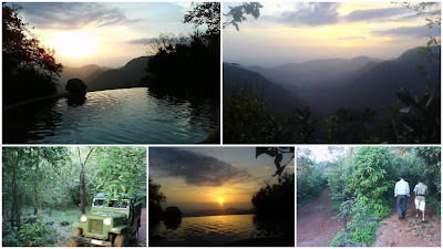
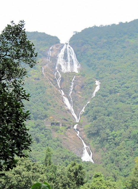
The climb up the jeep track was steep. We stopped in the middle to watch from a distance the funeral of a dead leopard arranged by the forest staff. Then up we went, a sheer climb with a near 180 degree turn finally bringing into view the Mouchuki Forest Bungalow. Painted green and with quaint dormers, it was such an interesting building in the middle of the forest. We stood there for some time watching the mist laden hills in the distance. Then it was time to go down. We took in a view of the hydro-electric power plant at Sakkham and then drove down to another camp with tented accommodation named Rocky Island. I had come to Rocky Island on my last trip to the Duars in the August of 2007. It had been drizzling all through the day and the tea plantations were a sea of green. The jeep track down to Rocky Island was overflowing in places. I had walked all the way down, wading through the water. And then, come walking up again! The stream below the Rocky Island camp had been roaring, its waters frothing white. In the late winter evening of 2009, there was no roar, no froth! Gigantic boulders rose from the bed of the stream as the waters gurgled on gently. The sun had set and it was time for us to drive back through the darkness. The cosy comfort of our Suntaleykhola cottage beckoned.


February 16
We left Suntaleykhola in the morning. Nabin took us to an interesting little factory in a nearby village, run by a Gorkha gentleman from his home. He specialised in furniture and show-pieces sculpted out of driftwood. Impressed by the ware on display, we placed an order for a small table to be delivered to Kolkata later on. We then drove down to a shop close by to procure a few cartons of the locally grown strawberry. (We had allowed ourselves only a few of the freshly plucked, juicy, crunchy strawberries during the tour, all the while looking forward to enjoying the rest with friends and family back in Kolkata. Sadly most of the consignment decomposed in the heat and dust of the plains on our way home!)
Nabin then drove us around the Samsing settlement where he lived. We went to an abandoned bungalow with sprawling lawns at the edge of a cliff offering a panoramic view of the Kumai hills. Nabin said that the bungalow was often used by film units when they came shooting in these parts. From Samsing, we took a shortcut to the Kumai - Jhalong Road. We were now on our way to Jhalong, Paren and Bindu. On the way, Nabin stopped at a local weekly market. Villagers had come from far and wide to buy and sell. On Nabin’s recommendation, we tried out some pork curry at a stall. We still remember the delicious pork we had that day, washed down with some lovely Bhutanese beer.
The next stop was the WBFDC bungalow at Jaldhaka. What an amazing location for a bungalow! The Jaldhaka flowed right below it. At Jhalong, a group of schoolgirls requested us for a lift till Paren. A transport strike was on and the roads were empty. So in one big noisy group we reached Paren, a sleepy village on the edges of the Neora Valley National Park. We ordered lunch at the WBFDC Wilderness Camp at Paren which stood in the middle of a clearing partly ringed in by a wooded hill. Standing in the midst of tall trees, and with the densely forested hillside towering up into the sky in the background, the Paren WBFDC cottages form one of the most enduring images of the tour for me.
After a satisfying lunch of rice, egg curry and the pickled fish Nabin offered us, we went to the see the dam which stands across the River Bindu connecting India and Bhutan. We crossed the dam and walked into Bhutan. A bank of fog was rolling in from somewhere. The sky was gloomy. A strong breeze blew through the valley. The place seemed so mysterious and so far removed from civilization, in spite of being home to a hydro-electric project. We seemed to have entered into a trance and ended up spending a long time here. As we retraced our steps to India, a tiny little Bhutanese doggie was following us like a pet. Durba wondered if we could keep it. Well, that was going to be slightly difficult!
Nabin wanted to take us to a nearby hilltop to give us a bird’s eye view of the dam and the Bhutanese countryside. We hurried on in the gathering gloom, rattling up a ruined metal road. Alas, we were too late. The light had faded completely by the time we made it. We were met by the twinkling lights on the dam below. There was just the sound of the wind and of our own breathing. I felt like I was living every moment. We started our long descent to the plains after some time. Our destination was the WBFDC Wilderness Camp on the river Murti, quite some distance away. Somewhere after Jhalong (may be before, I can’t recollect exactly), we were held up by ongoing repairs to a bridge. That set us back by another hour almost. But it also meant that we would be driving through the Chapramari forests late in the evening, prime time for animal spotting! It turned out Nabin and Durba did catch a fleeting glimpse of an elephant. But, as usual, I missed out! Tired and exhausted, we reached the Murti address at last at 10-30 in the night. The WBFDC staff had been kind enough to save some dinner for us.


February 17
We were up before the sun today. The birds were just beginning to chirp when I slid back the window of the sitting room in our first-floor suite at the Murti camp and peered into the darkness outside. Headlamps piercing the gloom, a line of jeeps were approaching from the other side of the river over the bridge near the camp. Our dawn destination was the Gorumara National Park. Nabin drove us into the Park just after the sun had risen. We went down to Gorumara’s famous rhino watching spot. Alas, no rhinos for us! Still, no regrets. Strands of mist hanging still on the rolling grasslands stretched for acres below us, a stream quietly meandering by, the mystic beauty of the place touched our hearts. Back to the camp, we spent the rest of the morning exploring the pebbled bed of the Murti through which a mere trickle flowed, a trickle which transforms into a torrent in the monsoon months when the river is in full spate and extends bank to bank.
Lunch made us extremely sleepy. But Nabin was waiting to take us to the Chapramari Wildlife Sanctuary for the afternoon shift. Wearily rubbing our eyes we boarded the jeep. The drive through the forest rejuvenated us and we arrived at the Chapramari watchtower harbouring great expectations of spotting some wildlife. The wait was not prolonged as a herd of bisons soon descended on the watering hole, joined shortly by a stray elephant. As evening fell, Nabin took us on a safari. Suddenly we spotted a solitary bison standing right on our path and stopped. One angry look from close quarters and it trotted off into a clump of bushes. WBFDC organizes a cultural evening by villagers at the edge of the sanctuary overlooking the Murti (Or is it the Neora river? I am not able to recollect clearly). A bevy of village girls danced to Nepali songs on a raised stage as we watched from our seats under a shed. Far away, the evening train to New Jalpaiguri slowly disappeared over the horizon.
We rode back to the Murti camp in the darkness. Reaching close to our camp, I asked Nabin to stop in the middle of the forest. He did so and switched off the headlights. It was such an amazing feeling sitting quietly in total darkness watching the dance of fireflies and listening to the music of the jungle orchestrated by myriad insects and other creatures. Were we being watched by unseen eyes from the woods? There could be so many possibilities! I recorded the sound of the forest on my phone. Nabin brought us out of our trance, switching on the headlights and turning the engine back on. It was after all not very safe being parked in the middle of nowhere in pitch darkness in what was elephant and bison country. Back in our suite at the camp, we settled down by the window of our sitting room. Would a herd of elephants come calling from across the river tonight? The prospect kept us awake for some time. But tired as we were, we ended our vigil soon and turned in for the night.


February 18
Today we decided to travel uphill again, all the way to Loleygaon. This was the one day on the tour that we had not planned for in advance. Nabin suggested we go to Loleygaon. Durba suggested we enjoy Murti for one more day. I said that we should try out Loleygaon, a decision we were not going to regret.
We set off after breakfast. Nabin drove through Mal Bazar and, after Gorubathan, we started climbing steadily. It was a picturesque journey and we kept stopping at places en route to take in the scenery. We had noodles and some yak cheese at a small village on one of our halts. Around noon, we reached the town of Lava. We had started in light clothing in the morning. It was windy up here in Lava and the chill in Lava made us scramble for our jackets and pullovers. After a short visit to the Lava monastery, I asked Nabin to see if he could arrange to take us to a place I had earlier read about – the Chaudapheri Camp inside the Neora Valley National Park (Lava is one of the entry points of the Park). Nabin took us to the Range Office, Upper Neora Range, from where passes are issued for visits to the Park. The formalities took some time as no one was to be found in the office initially. Finally we were on our way, the tour party augmented by a guide and a couple of Forest Department staff.
We slowly rumbled up a jeep track that was so steep and sharply twisted in some stretches that it looked almost impossible to negotiate. Here, on this path that no one seemed to tread on except the stray villager, and in the midst of towering pines, clouds seemed to have found a cosy nesting ground for themselves. Drenched in mist, we crawled upwards through this melancholy world, the chill intensifying at each bend. I don’t remember how long we drove. Time seemed to have stopped. Suddenly the mist thinned. We had emerged out of the clouds and stopped at a clearing in the middle of the forest basking gloriously in the afternoon sunshine. Standing in front of us was a log hut with signage which read: ‘Chaudapheri Camp, Upper Neora Range, Wildlife Division II, Established - 2002, Altitude - 2372 m’. Some distance away, there were steps leading up to another hut which seemed to be a recent addition. This was the Red Panda Camp inside the Neora Valley National Park, a natural habitat for red pandas which, I believe, are an endangered species.
Treks through Neora Valley National Park start from here. If trekking for more than a day, one can halt at forest villages deep inside the Park. One of the names I can remember is Rochella. In fact, trekking all the way through the Park, one can emerge at Mouchuki, which we had visited earlier. One can also emerge at Todey, near Paren. But I had read that it is not an easy trek all the way. We decided to see what it was like for the first few kilometres. And so, with the sticks that our guide had given us each, we started to climb. Slipping, swaying, tottering we went, making a spectacle of ourselves to our guide out of our total inexperience! Under a canopy of leaves so dense the sun did not shine through, walled in by an impenetrable screen of bamboo on both sides, our path was a treacherous moist carpet of leaves and twigs and moss.
At one point, our guide invited us to follow him up a tree inclined at an angle across a sheer drop, promising a majestic view of the Kanchenjunga from the other side if the weather was clear. Durba didn’t seem confident. So I told her to wait at the bottom of the tree and shout just in case she saw any ‘kala bhalu’ or black bear approaching, a possibility our guide was happy to share with us! I managed to scramble through but, alas, no Kanchenjunga! The side we had come from was shileded from view by dense foliage. Suddenly, we heard Durba screaming from somewhere close. Alarmed, I shouted to know what had happened. Continuing to scream, she informed that she was fine, but we should get back immediately. We complied and, on the way back, found her perched on the middle of the skywalk. Apparently, she had mustered enough courage to try and join us, but had slipped in the middle and almost fallen off!
We took some rest after this incident and decided to head back, making heavy weather of our ‘trek’ as were from our utter lack of preparation and application. Durba wondered what if she had really met a ‘kala bhalu’ on the bridge. I told her I didn’t know about black bears, but she had surely frightened the entire population of red pandas (sadly whatever remains of it) out of the Park and into neighbouring Sikkim with her screams! Nabin, who had found the incident amusing, drove us down to Loleygaon. Travelling through a pine forest that looked looking mysterious in the fading light and gathering mist, we reached our destination after sunset.


February 19
Today was the last day of our tour. We woke up in our cottage at the Loleygaon WBFDC address to find the Kanchenjunga hidden behind clouds. The sun was shining and it was a and beautiful morning. Only the Kanchenjunga was not to be seen! As in Suntaleykhola, we had the entire WBFDC property to ourselves. There were no guests in any of the cottages. The night before we had stood watching the beautiful star-studded night sky from the garden of our cottage as the lights of Kalimpong twinkled in the distance.
After breakfast Nabin took us to a local park famous for its tree bridges – a network of walkways suspended from the trunks of enormous trees. It was fun walking from tree to tree high above the ground. Finally it was time to say goodbye to Loleygaon. On our final journey with him on this tour, Nabin said he wanted to give us a taste of adventure. And so, we took a route that not many would probably be willing to take on the way down from Loleygaon! This was the jeep track that wound its way past Charkhole, through Borbot, through the Chel forest, past Chuikhim, finally meeting the plains at Bagrakote on the banks of the Lees river. We didn’t even know such a route existed. The scenery was breathtaking but progress was slow, the jeep track fit for mainly battle tanks! Not surprisingly, we seemed to be the only travellers on this road. Nabin drove patiently, but to say the ride was bumpy would be an understatement. However, the view amply compensated us for the discomfort.
Passing by Charkhole and some small hamlets, we reached Borbot, a bigger village with a market. But not before Nabin had lost his way at a fork in the middle of nowhere and driven up a wrong track, the result being that we had to drive almost a kilometre in reverse, there being no room to turn round. We can’t blame him. We were not carrying a map and even if we did, I doubt whether this route would be shown. To complicate matters, there wasn’t a soul for miles that we could seek directions from. Had it not been for a party of villagers out to gather firewood, we could very well have driven all the way back to Lava!
After a brief stopover during which we helped ourselves to some noodles and tea at a roadside shop, we entered the most exciting leg of the journey which passed through the dense Chel forest. A Forest Department staff who had a hitched a ride with us from Borbot informed us (through Nabin, who translated it from Nepali) that a tiger had been spotted in the area recently, probably having made its way down from the Neora Valley National Park. I wondered what it would be like to get stranded in the middle of this forest in the evening with a broken down jeep. As it is, it hardly seemed to receive human footfall apart from villagers and the forest personnel and there was no mobile connectivity.
We bid adieu to our forest guard after the Chuikhim village. Some villagers were erecting a shed for trekkers. Apparently, an eco-tourism initiative had been launched in Chuikhim and treks introduced through the forest here. Soon afterwards, we could see the Lees meandering its way through the plains below. We were on our way out of the forest and emerged at the busy town of Bagrakote from where we turned on to the National Highway. We were leaving the beautiful Duars behind. One last halt was made at the Mongpong WBFDC facility close to Sevoke.
It was after crossing the Sevoke bridge that we encountered a serious problem in the form of a traffic snarl which seemed to have clogged all routes to our destination, Bagdogra. With a flight to catch at 3-30 in the afternoon, we were tense. As the minutes ticked by, I asked Durba to call the Spicejet number, almost sure that boarding had closed and the flight would take off without us. To our utter relief we were informed that the flight to Kolkata was delayed by half an hour. In the end we made it just in time. Thanking Nabin for the great service and hospitality, we ran inside the terminal for a just-in-time check in. Half an hour later, we were flying back home, to the heat and dust and humidity, to the smog and the noise of a metropolis. The forests were etched in our memory forever. Even today, when I close my eyes at times, I am transported back to Neora Valley, and Chel forest, and all those beautiful places we had been to…


Tour Itinerary
DAY 1: NSCBI Airport, Kolkata (CCU) - Bagdogra Airport (IXB) - Sevoke - Mal Bazar - Chalsa - Matelli Bazar - Samsing - Suntaleykhola WBFDC
DAY 2: Suntaleykhola WBFDC - Mouchuki Camp (Neora Valley National Park) - Sakkham - Rocky Island - Suntaleykhola WBFDC
DAY 3 - Suntaleykhola WBFDC - Samsing - Kumai - Jhalong - Paren - Bindu - Jhalong - Khunia More - Murti WBFDC
DAY 4 - Murti WBFDC - Gorumara National Park - Chapramari Wildlife Sanctuary - Murti WBFDC
DAY 5 - Murti WBFDC - Mal Bazar - Gorubathan - Lava - Red Panda Camp (Neora Valley National Park) - Lava - Loleygaon WBFDC
DAY 6 - Loleygaon WBFDC - Loleygaon - Charkhol - Barbot - Chel Forest - Chuikhim - Bagrakote - Mong Pong WBFDC - Sevoke - Bagdogra Airport (IXB) - NSCBI Airport, Kolkata (CCU)
(Special circumstances had forced us to book a flight to and fro. The alternative is to take an overnight train between Kolkata and New Jalpaiguri/New Mal Junction.)
Tour Map (all the roads and jeep tracks we travelled on are not shown)

  Google Earth Tour